National Parks

Death Valley National Park

Overview

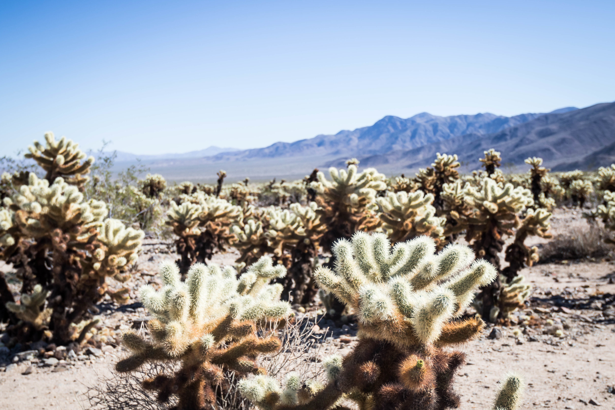
Death Valley is the largest national park outside of Alaska with countless exploration and experiences to share for all ages.  The park covers 3 million acres of Wilderness that include majestic sand dunes, twisted and narrowed colorful canyons, rocky peaks, stunning salt flats, and more.   

Accessibility

All of the major highlights at Death Valley is wheel chair accessible and very kid friendly. You can literally see the beauty of Death Valley from your car or a quick walk outside your car.

Death Valley is close to 2 major cities (LA and Las Vegas) so getting here could potentially be a day trip if you leave early in the morning and stay late in the evening.

Death Valley is open all year around but summer is blazing hot and can get up to 130 degrees F so we recommend going in the fall or winter or early spring. We were here in November and it was 79 degrees during the day and cool at night. It was perfect weather.

Park Highlights

2018_DeathValley_a-227.jpg

Sand Dunes

Mesquite Flat Sand Dunes – Death Valley is home to 5 sand dunes, with one of them being perhaps the tallest in North America, Eureka Dunes. While at Death Valley, we visited Mesquite Dunes because it was 5 miles drive from Stovepipe Wells Campground.  Mesquite Dunes is in the middle of the valley and offers a stunning 360 view of the different mountain ranges that overlook the park.  Harvey loved the dunes so much that we often found him swimming down the dunes and rolling wherever gravity takes him. If you plan to visit the dunes, please bring sandals and be prepare to hike if you want to be on/near the highest peak.  

Badwater Basin

Badwater Basin

Badwater Basin– This is the lowest point in North America, 282 ft below sea level.  The basin is a surrel landscape of vast salt flats.  Harvey was fascinated by the salt and had to taste test a few areas of the flats. He also enjoyed walking on top of where the salt raises up on the flats.  

Dante’s View – A breathtaking drivable viewpoint in the park that offers a mountain-top overlook that is more than 5,000 ft above the floor of Death Valley. This vista point is highly recommended for both sunrise and sunset on a clear day. 

Artist’s Drive – This is a scenic 9 miles loop drive that takes you through colorful volcanic and sedimentary hills. Towards the middle of the loop, there are hiking trails that allows you to see the colorful sediments that creates the beautiful mounts.  Unfortunately we only had 1 hour to spare for this drive and therefore didn’t get a chance to hike any of the trails.  We will definitely be back and hike a trail or two in the future.

Zabriskie Point

Zabriskie Point

Zabriskie Point – This is a beautiful vista point for catching both sunrise and sunset on a clear day.  The beautiful golden colored badland hills is probably one our suggested must-see sights because of its ease of accessibility, which is a 0.25 mile hike from the parking lot that can’t be missed if you’re coming to the park from the east entrance, Las Vegas.

Twenty Mule Team Canyon – If you’re interested in a fun drive through beautiful golden canyons, the Twenty Mule Team Canyon loop is an easy one not to miss.  This loop is less than 5 miles east of Zabriskie Point, and offers a close look at Death Valley’s vibrant golden canyons. There are a few areas with steep and curvy trails, so please leave your 25-ft trailer at the campground.

Two other areas that we visited while driving through the park were Devil’s Golf Course and Salt Creek.  Devil’s Golf is a quick drive to and checkout point and Salt Creek has a 1 mile loop walk on top of a creek that runs through the park.  During the wet season, pupfish can be found at Salt Creek. 

We were unsuccessful at being able to visit Titus Canyon and Mosaic Canyon.  The drive-in trail to the trailhead for Mosaic Canyon is under renovation, so if you still want to visit the canyon, you’ll have to hike an additional 2 miles from the main road to the trail head. Titus Canyon requires a 1 mile off-road drive from the main road to the trailhead so please be prepare for some rocky driving. I would recommend an 4x4 with some clearance on this road.  If you just have a sedan, please drive slowly and navigate around large rocks.   

Lodging

2018_DeathValley-12.jpg

Wildrose Campground – We stayed at Wildrose campground because it was the closest campground from the west entrance.  Wildrose campground is one of several free campgrounds in the park.  Wildrose offers a phenomenon snapshot of the milkyway because of its pitched black skies. We would recommend staying at this park if you’re coming from the west entrance and want to see a lit up sky.  The road to this campground is not well maintain and is pitched black at night so please drive slowly and be prepare to navigate around potholes. 

Stovepipe Wells Campground – We stay at Stovepipe Wells our second night because it is near some of the places we wanted to visit, like the Mesquite Flat Sand Dunes and Mosaic Canyon.  Additionally, Stovepipe Wells also has gas and facilities if you’re looking for a warm shower and a convenience store.   

Furnace Creek Campground – We then stayed at Furnace Creek because of its vicinity to additional places that we wanted to visit near the east side of the park, such as the Salt Flats and Zabriskie Point.  Furnace Creek is a very large campground, but do fill up during peak season so please plan accordingly and come early to snatch a site if you don’t already have a reservation. The Ranch is a resort down the road with a very large and warm swimming pool and shower for $5/person, and the main visitor center is next door to the campground.  

Closest Cities to the Park: 

The closest major city to the east entrance of Death Valley is Las Vegas, which is 123 miles.  Closest major city to the west entrance of the park is Los Angeles, which is 218 miles south west of the park.

Recommended Length Stay: at least 3 days and if possible 5 days or more.

Would we be back?  Definitely yes and spend more time in the park.

For additional photos, click here.

Joshua Tree National Park

Overview

Covering approximately 800,000 acres, Joshua Tree National Park is considered a desert wilderness where the high Mojave Desert meets the low Colorado Desert.  This desert can be described as smooth large boulders, rugged mountains and desert plains covered with Dr. Sues’ trees, Joshua trees.  Each year, the park welcomes approximately 2.8 million visitors to activities like hiking, camping, day and nigh photography, rock climbing, and the simple pleasure of desert scenery and wildlife.

Accessibility

Joshua Tree is relatively accessible by car and most of the roads inside the park are paved. Joshua Tree is open all year around but the best time to go is during the fall and winter because the weather is cooler than the spring and summer which can be extremely hot, can be up to 120F. We went during November and it was perfect weather around 75-80F during the day and around 60s at night.

Park Highlights

Forty-nine Palms Oasis

Forty-nine Palms Oasis

Fortynine Palms Oasis – This is a 3 miles round trip with 300-ft of elevation gain each way.  At the end of the hike is a rocky canon covered by green palm trees.  Even though it was November, temperature throughout the hike felt like mid 80 degrees.  It is suggested that you do not attempt this hike when it is hot out.

Barker Dam Hike – This is a 1.1 mile round trip loop that takes you to a man-made water tank/dam that was built by the early cattle ranchers.  Although the hike is deep into the park, the entire hike is flat, easy and scenic at the dam. 

Cholla Cactus Garden – This is a ¼ mile loop with thousands of concentrated cholla cactus, also known as jumping cactus.  Please be very careful not to come close to these cactus and where  

2018_JoshuaTree-178.jpg

Cholla

Keys View –  This is a beautiful viewpoint on the Little San Bernardino Mountains that gives visitors a panoramic view of the Coachella Valley.  It is popular place to hangout and enjoy both sunrise and sunset.  

Skull Rock – Along the main east to west park road is Skull Rock, which is a fun rest stop when driving through the park. Skull Rock can be seen just across the road and there are many fun nature trails all around this rock to explore.  Harvey had a blast climbing in between the boulders surround Skull Rock.   

Lodging

2018_JoshuaTree-10.jpg

BLM Site

Joshua Tree BLM – We arrived in Joshua Tree National late Saturday night during what’s considered peak season, the fall and early winter, and therefore could not find a campsite in Indian Cove. We decided to experience our first BLM camping.  There are lots of BLM lands near Joshua Tree and you can find them on Google Map.  Overall, the BLM near Joshua Tree exceeded our expectation because it was free and there were quiet a bit of other people around us.  If you decide to BLM, please make sure your vehicle can handle rocky and sandy roads.

2018_JoshuaTree-133.jpg

Indian Cove Campground

Indian Cove Campground – We spent the remaining two nights at Indian Cove Campground because the campsites were situated right next to beautiful large boulders.  The sunsets at Indian Cove was breathtaking because of how the sun’s colors are reflected off the soft towering boulders surrounding each campsite.  There are many campgrounds in Joshua Tree and most have many first come first serve basis campsites.  If you are planning to visit during peak season, which is from the fall to spring seasons, please plan to arrive at the campground early to snatch a campsite, especially on the weekends.  Please check with the https://www.nps.gov/jotr/planyourvisit/campgrounds.htm for additional information regarding campgrounds in Joshua Tree National Park.  

Closest Cities to the Park: 

The closest big city to fly into to visit Joshua Tree National Park is Los Angeles. 

Recommended Length Stay:  At least 3-5 days to hike and explore the majority of the park.

For more photos, they can be found here.

Pinnacles National Park

Overview

Although it was established as a national monument in 1908, it wasn’t until recently that Pinnacles became a national park, 2012.  The park is located in central California, and is divided by rocks formation into the East and West Divisions.  There are only foot trails that connect the East and West Divisions, no road.  A notable attribute of Pinnacles National Park are the many caves that are homes to many species of bats, some of which are only found at Pinnacles.  

Accessibility

There are two entrances to Pinnacle National Park, East and West.  Both roads are small and it is best to enter the park during the day-time because the roads are not well lit.  There are a few vista points that are drivable to, but the majority of them require some hiking.  Pinnacle has two visitor centers, one on the East and the other on the West.  Camping is only allowed at East Pinnacles. 

2018_Pinnacles-58.jpg

Park Highlights

Wild animals and bats – This park is one of Harvey’s favorite parks because of the wild animals that we saw everywhere.  From the dozens of deer feeding no more than 25 feet from our campsite to countless bats that come out at night to feed on the bugs, Pinnacles is a home to a lot of animals, and Harvey had a blast looking at them.   

Bear Gulch trail – This is a 3 miles round trip hike that took us through a cave and ended with a reservoir.  This is a kid friendly trail and we saw an entire school bus of kids hiking this trail for a school field trip. It was Harvey’s first cave hike and he enjoyed the dark and low ceiling navigation. We definitely recommend this hike especially if you have not hiked through a cave before.  Make sure you bring a flashlight.  

2018_Pinnacles-171.jpg

Old Pinnacles Trail to Balconies Cave – This is a 4 miles round trip hike and again took us through a cave.  We skipped the uphill balconies portion of the hike, because we weren’t sure if Harvey could handle another 0.8 miles hike.  The highlight of this hike was the ¼ mile hike through dark and tight spaces. The cave for this hike is definitely a little more tricky and harder to navigate because of the tight spaces. The trick is to follow the white arrows and some can be challenging to find in the dark.  Again, please make sure you bring a bright flashlight. 

Lodging

We stayed at the RV campground at Pinnacles because we wanted to plug-in our trailer and keep the freezer/fridge cold.  It was challenging to find an RV site on a first come first serve basis for more than 2 consecutive nights because 1/3 of the RV campsites were closed because of falling trees. As for tent sites, the park has quite a bit so it shouldn’t be a challenge visiting without making prior reservation. 

Closest Cities to the Park: 

The closest major city to Pinnacles is San Jose, California, which is 85 miles north of the park. You can fly into SAN international airport and drive to Pinnacles in 2 hours.  Please be prepared to deal with terrible traffic during rush hours so please plan accordingly.

Recommended Length Stay: 3-5 days

Would we be back?  Maybe when Harvey is older and can handle the dryer climate as wells longer hikes.

For more photos of the park, click here.

King's Canyon National Park

Overview

Originally founded in 1890 as General Grant National Park to protect giant sequoia trees, the park was later expanded and renamed to the Kings Canyon National Park in 1940.  The park is located in the southern Sierra Nevada near Fresno, California. Kings Canyon offers rugged glacier-carved valley that more than a mile deep with beautiful features that include many 14,000-ft peaks, swift-flowing rivers and some of the world’s largest and oldest giant sequoia trees. Beside the many vista points down the long canyon winding canyon drive, Kings Canyon National Park boast countless long and scenic backpacking trails for those hungry for days in silent with nature’s peaceful landscapes. 

Accessibility

We were extremely lucky with our visit at Kings Canyon because we had the chance to drive through the largest part, the later expanded part of the park, of Kings Canyon on the last day before the road was closed for the winter season.  Although the park is opened year round, the vast majority of the park is closed for the winter due to unpredictable weather, so please check with the nps site and plan ahead.   

Overall the park provides is both friendly for those who like to drive and especially for those who like to hike. One of the most famous hike at Kings Canyon is the Rae Lakes Loop that starts at the end of the drive down the canyon. This is a 41.4 miles loop with over 6,000-ft of elevation climb to a breathtaking view of Rae Lakes. If you plan to do this hike during the summer, please make sure you make reservation through the nps site because permits are limited.    

Park Highlights

2018_Sequioa_Kings_a-106.jpg

Scenic Drive through King’s Canyon

Kings Canyon Drive - Driving through Kings Canyon was like go through a 5 hours stop and go rush-hour traffic afternoon. Every mile seems to have a must stop vista point.  Although our visit was in the dryer season for the park and most of the waterfalls have dried up, the entire drive down and up the canyon was exciting and picturesque. The winding roads and colorful rocks that fenced the drive on Kings Canyon Scenic Byway is definitely worth a day trip. 

Roaring River Fall - While down the canyon we stopped by the Roaring River Fall for what that was supposed to be a 30 minutes lunch break but became an hour relaxation lunch spa experience. Since it was the dryer season, we were able to hike closer to the water and allow the soothing sound of cold glacier water falling on the smooth rocks relaxes our minds while we enjoyed our scrumptious lunch.  

2018_Sequioa_Kings_a-24.jpg

King’s Canyon WaterFall

2018_Sequioa_Kings_a-45.jpg

Roaring River Falls

2018_Sequioa_Kings_a-60.jpg

roaring River FaLLS

Lodging

We stayed at Azalea campground and found a beautiful fist come first serve campsite.  Azalea campground is open year round is in the part of Kings Canyon that was initially the General Grant National Park.  The campground is about 1 mile from the visitor center, hotels and cabins, restaurants, gift shop, and post office. This campground is surrounded by giant pine trees and situated next to the second largest standing sequoia in the world, General Grant.  If you are camping during the weekend, please plan to come early to snatch a campsite because the campground can fill up quickly.    

Closest Cities to the Park: 

The closest airport is the Fresno-Yosemite International Airport (FAT), which is about 65 miles south of the park, which equates to a 1½-hour drive.

Recommended Length Stay:  At least 3 days if you’re just planning to drive around the park, and at least 5 days if you’re planning to do some backcountry camping and hiking. 

Would we be back? Absolutely when Harvey is older and can backpack with us for more than 3 hours.

For more photos, they can be found here.

Lassen Volcanic National Park

Overview

Lassen Volcanic National Park was established on August 9, 1916, and is located northeast of California. The park has geothermal/hydrothermal areas, lava beds, mountain views, and volcanoes. 

Accessibility

Although the park is open all year around, the winter months have limited access because of extreme and unpredictable weather. Many of the facilities are only open in the summer so please check the NPS page before you visit.  

We did not get to hike the Bumpass Hell Trail to see the famous geothermal/hydrothermal area because it was closed for renovation through December 2018. We were informed that there is an alternative route to the Bumpass Hell Trail geothermal/hydrothermal areal, but that requires some backcountry hike through and with a 4 years old, we were not ready for any surprises mid-way through a long hike.  

Overall, this park has kid friendly trails but according to our 4 years old son, it did not have a wow factor. 

Park Highlights

2018_Lassen-71.jpg

Lassen Peak Trail

  • We hiked Lassen Peak, the largest plug dome volcano in the world as well as the southernmost volcano in the Cascade Range. Harvey was able to hike about 1 mile before he got bored and the climb got harder beyond the 1 mile marker.

  • Cinder Cone was our favorite hike and also our top highlight at Lassen. Harvey really enjoyed climbing up the Cinder Cone and leaving mommy behind in the dust. He learned about the lava and thought they were really neat. This hike can be very difficult if you’re not in good shape or have bad knees since the climb is quite steep and on gravels. Harvey is a climber and loves to climb mountains and stairs so please use your own judgement for your children.

  • Manzanita Lake has a great photo opportunity when the lake is calm to reflect the mountain above it. Unfortunately, it was very windy during our trip so could not capture the reflection you often see online. 

  • Lastly, the park offers great night photography of the Milky Way and one of the best places to do so in at Chaos Crags. We did not get a chance to do this because we have a little one and hiking there would be challenging when his bedtime is at 8:30pm. :-) 

2018_Lassen-128.jpg

Cinder Cone

2018_Lassen-141.jpg

Harvey is loving the hike up

2018_Lassen-177.jpg

Top of Cinder Cone

Lodging

Manzanita Lake Campground is a popular place to stay when you’re at Lassen because of the famous Manzanita Lake where you can hike to get a view of Lassen Peak. We stayed here and thought it was very nice but the bathrooms were extremely cold in October and all the facilities like showers, laundry, store and visitor center were closed. We had to drive to the southwest entrance to Kohm Yah-mah-nee Visitor Center. 

Closest Cities to the Park: 

Redding and Susanville

Recommended Length Stay: at least 3 days

You can do the view points in one day but if you want to visit all the highlights we mentioned above, it will take you at least 3 days without rushing it. 

Would we be back? Maybe if we had time and was driving through Redding.  


For more photos, they can be found here.

Redwood National Park

Redwood National Park has so much to see and three days was not enough to see everything. Between the world’s tallest tree,  fern canyons, beaches, and wildlife, you can easily spend a week here and still haven’t seen it all. 

2018_Redwood_day3-58.jpg

We decided to stay at two different campsites since we wanted to experience different parts of the park. At our second campground, Elk Prairie Creek, we had elks hanging out near our campground while we prepared and ate dinner.  In the evening and later that night, we had gray foxes playing right outside our trailer. Additional animals included deers and blue jays that were curious at what we were eating. It was an amazing and memorable experience for all of us.

Hiking in the Redwood is most amazing in the afternoon and early morning because of the fog and moisture in the air.  This creates beautiful sun rays through the trees and parries. Additionally, there are often less people on the trails and less noise which means more animals to see! 

If your’e not a hiker, well, Redwood has a drive that will take your breath away through giant redwoods called the Howland Hill Rd. The drive is narrow and only one car can go through at once squeezing between the TALL tress. It is so much fun for both kids and adults. Our son was amazed by the countless tall trees. Some of the trees, you can’t even see the top of it! 

2018_Redwood_day2-24.jpg

Fern Canyon

We also did a hike to the fern canyons, a quick drive from Elk Prairie Creek campgrounds. The ferns are really something different and definitely worth going to but make sure to have an SUV because the roads are really bumpy and you have to drive through small creeks depending on the season. Smaller cars can get stuck or have to turn around. The canyon has a few inches of water flowing down the canyon so please bring rain boots or sandals so you can make it through the canyon without worrying about getting your shoes and socks wet. We wore waterproof hiking boots and it was a little challenging balancing on those rocks and tree trunks. 

2018_Redwood-13.jpg

When people think of Redwoods, they think of trees but part of the park extends to the beach area which we recommend stopping by for lunch to hand out watching surfers ride the waves or just play in the sand. 

Our recommend length of stay at Redwood National Park is at least 4-5 nights, to allow you to enjoy amazing hikes, drives around the park’s beautiful natural landscape and relax. 

For more photos, they can be found here.

Crater Lake National Park

2018_Crater_Lake-80.jpg

This was our 2nd time at Crater Lake and it’s still amazing to us. The prestine crystal blue water is a sight to see when you hike down and from the rim, the dark blue color is breathtaking. 

The rim drive is a must do and something that took us around 2 hours to do even with a toddler stopping at almost all of the view points. We did the pinnacles trail and that was very short and sweet hike to see pinnacles emerging from the ground. A really good hike for kids.

We did not hike down to the waters this time around but we did do that last time we were here and I would recommend hiking down to see clear the blue water. Hiking down is very easy and gravity just pulls you down but hiking up is SUPER steep and will take you double the time to do. We went in the summer time and there were sooooo many bugs while hiking so be prepared to bring bug spray. In the fall, we did not see as many bugs this time around so I feel like colder weather is better to hike at Crater Lake. 

Crater Lake campgrounds closed after Oct 1st and since we came a few days after and so we booked the Crater Lake Lodge, the only available lodging option at Crater Lake. It is a very old hotel which is ran by the parks services and closes in the winter time due to weather and driving conditions and therefore, the prices are expensive for a 2-star quality hotel. I would recommend camping at Crater Lake instead of staying at the lodge so go before Oct 1st! 

Our recommend length of stay at Crater Lake is 3 nights which will allow you to relax and enjoy the rim, hike down, and go to hikes in the park but you can also take a day trip here from Portland as well if you move quickly. 

Beyond Crater Lake is a hidden gem that we highly recommend driving the extra hour to get to Umpqua Hotsprings. There are 8 pools with different temperature (hottest is the first pool and then gets colder as you go down since the hot water runs from the top). It is a very short 3/4 mile hike up to it and pretty easy going down during the non winter months. Winter months, it can take up to 2 hours because of how steep it is. Our 4 yrs old toddler had no problem walking on this trail and he loved the hot springs. For more photos, they can be found here.

2018_Umpqua_Hotsprings-27.jpg

Relax and soak in some perfect temperature water

Mount Rainier National Park

2018_Mt_Rainer-49.jpg

Fall colors at Mt. Rainier

Mt. Rainier was no where to be found

Mount Rainier was the first stop on our 7 months road trip. We were excited to start this adventure and everything would go smoothly as planned. On our first day at Mt. Rainier, she (“Mt. Rainier”) did not want to come out to say hi. We drove from one viewpoint to another in search for the best portrait of her and yet the clouds quickly covered her at every viewpoints we stopped. The park ranger said, “she has a mind of her own”. Luckily, the beautiful fall colors were there and we were able to see the fall season of Mt. Rainier, something we have never seen before. The colors were amazing and we couldn’t be happier to see them.

2018_Mt_Rainer-120.jpg

She came out

to say hi!!

That evening, it rained like cats and dogs, and setting up camp was tough because it was the first time we actually used the cricket and putting up the awning was not simple. Even though it rained and we weren’t able to get a fire started, we felt pretty warm and dry inside our Cricket camper trailer. Again, thanks Mother Nature for testing us.

The next day, as we were heading out of the park, we saw Mt. Rainier right above us. She came out and we said, “hello there!”. So, we took off on another short chase for the best portrait of her and made a fun game out of it with Harvey. During our chase, Harvey wondered why we were chasing a mountain, we responded with “because it’s fun”.

We will be back in the fall again to visit her because it’s a colorful time of the year to visit Mt. Rainier. I would highly suggest anyone coming to visit Seattle to put Mt. Rainier on their itinerary. It is a 3 hrs drive that is worth every minute! To see more photos, please go here.